Sunday, January 12, 2014

Lithological modeling

Granitic morphological system


Granite is an igneous rock mainly made of quartz, mica, and feldspar. It rises to the surface because of the tectonic movements. This modeling is a consequence of how it is made and how it behaves. It leads to different landforms:

  • Dome: The granite rises and it erodes dome shaped.


  • Spheroidal weathering: these granitic structures are caused by the erosion of the dome. It provokes cracks that divide the block into smaller ones which appear organized stacked up


  • Balanced rock: the rock breaks and starts rounding collapsing the structure, so the stones on the top, are in balance over the rest of the rock.


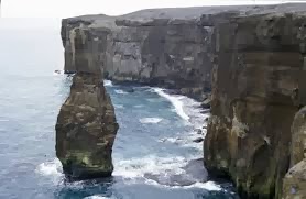
  • Pinnacle: rock structure tower shaped.


  • Flat stone: big, smooth, plain and long rock formed because of the breaking down of granites.


  • Inselberg: some of them also have a granitic origin.

  • Tafoni: Also formed in granitic-origin rocks thanks to different chemical processes.


  • Tor: Water breaks the granitic rock down when it goes through the cracks that appear on it.


Karst morphological system


Geological formation shaped by the dissolution of a layer or layers of soluble bedrock, usually carbonate rock. The name comes from the Karts region in Slovenia. In Spain, karst landscapes can be seen in Cuenca, Antequera…

  External Karst

  •  Limestone pavements


  •  Pit cave: vertical well that appears on carbonate rocks (water erosion).


  • Upwelling: Water comes out the galleries through these areas.


  •  Sinkhole or doline: Circular depression because of the dissolution of the top part. It can also be formed by a cave collapsing due to materials weight.


  • Polje: Bigger hollow that has a plain bottom.


  • Uvala:  Collection of multiple smaller individual sinkholes.

  • Tormo: Vertical carbonate rock reliefs formed because of the dissolution of the rock bottom part.


  • Torcal (tower karst): stone stacked up.


Internal Karst

Water seeps into the caves and floods the galleries as a consequence of the rise or fall of the water level. When it reaches the phreatic zone, the water accumulates and starts to run horizontally.

  • Stalactites and stalagmites: type of rock formations that hangs from the ceiling of caves (the first ones) or rises from the floor of a cave due to the accumulation of material deposited on the floor from ceiling drippings.

  • Pit cave: vertical well which leads into deep caves and galleries.


  • Column: union of a stalactite and a stalagmite.


  • Travertine: Form of limestone originated when water evaporates and the bicarbonate precipitates.


Coastal Morphological Systems

This type of modeling doesn´t rely on the clime. It depends on other factors such as the waves, the tides and the currents.
  1. Agents: Water is the main agent. It can´t produce erosion unless it carries different materials.
  2. Processes: Intense chemical weathering (thanks to the presence of water) and biological weathering (for instance: limpets, a type of mollusk, stick to rocks and erode them). The erosion caused by the waves forms:
    • Cliff: Sea shores with steep slopes. Water undermines the bottom part of the rock, so it loses balance and breaks. Gravity acts and the materials fall down forming an abrasion platform.


    •  Arc: It is formed when the waves crash against a land rise and change their course, heading towards an area on the walls that they will erode.


    • Stack: Formed by the extreme erosion of an arc. It is a vertical column of rock in the sea near a coast.


    • Caves: they are formed because of the constant crash of the waves against a certain point on the rock.


   Landforms caused by transport and sedimentation:
    •   Beach: Places where the materials brought to the coast by the waves are sedimented. It is divided into three different parts:


                    -  Foreshore: It´s the closest area to the sea and it floods with the high tide.
                    -  Berm: mound that separates the foreshore and the backshore.
                    -  Backshore: Furthest area from the sea, with some vegetation.


                    - Dunes: Originated by the action of the wind on the deposited materials.


    • Bays and coves: These areas are more protected from the waves than beaches. They have a bigger curvature than beaches.


    •   Sandspit: It´s a type of bar or beach parallel to the coast formed by the accumulation of materials because of the process of longshore drift. This process consists of the transport of sediments by waves along the coast at an specific angle in relation to the shore line, but they go back parallel to it, in the direction of the maximum slope. Sandspits create lagoons.


    •  Marsh: Type of wetland (flat area saturated with seawater).


    • Tombolo: Islet attached to the coast by a sand bar.


    • Coral reef: Underwater structures made from calcium carbonate secreted by corals. Corals grow in warm very oxygenated and clean seas.


Monday, December 9, 2013

Humid Mophological Systems

A Humid MS is a warm area where the main geological agent is water.

Water acts in three different ways:
  • Torrent: Consolidated channels but water doesn´t run permanently. It has serveral parts:

    • Catchment basin: Receives the rainfall water. The watershed makes everything go through the same canal.
    • Drain: It presents different landforms:
      • Pools or giant´s kettle: Areas where the water erosions creating this holes. The lower pressure makes the water move the little stone inside the pool making it deeper.

      • Rafts: They are formed when there´s a bigger slope and the water has more energy thanks to this height difference.


      • Waterfalls: water falling from an important height, formed when a river or stream flows over a precipice


    • Alluvial fan: cone-shaped deposit where the water puts down the sediments when it loses its energy.


  • Wild water: Watercourses but without a permanent basin. It produces different geological effects:
    • Gullies: Waterfalls everywhere digging furrows on the slopes or badlands.

    • Fairy chimneys are also formed here (badlands).

    • Limestone pavement: Grooves formed on the rocks (limestone) by dissolution.

  • Rivers: Permanent basin and continuous water flow. 

          Some important considerations are:
    • Balance profile.  Rivers tend to have as much erosion as sedimentation all along their basin. They rarely get this balance profile because of the tectonic movements.
    • Rivers erode backwards. Water removes material from the top of the river.
    • Landforms:
      • Waterfalls
      • Bends: Curve structures of the rivers. They are formed by the collision of the water against a wall which starts eroding. Near internal wall, where the water has less energy there is sedimentation. That´s why the curves get bigger every time (middle course).

      • Floodplains: When there is an inundation, the water leaves sediments on both sides of the river.


Desertic/Arid Mophological Systems

A Desertic MS is an area characterized by a lack of available water, and where the main geological agent is the wind.

The geological processes include:
  • Thermal stress: sharp temperature changes (mainly daytime and night) provoke expansion and contraction of rocks and, eventualy, their rupture.

  • Haloclasty: salt crystallization causes rocks to break up when saline solutions in cracks evaporate and salt crystal expand and increase pressure on the rock.


Other geological effects are:
  • Desert varnish: thin film like a shiny coating formed in the surface of stones due to the action of bacteria

  • Salt lakes: wide areas covered of salt due to evaporation.


Structures formed on the desert slopes:
  • Tafoni: Hollows formed on the rock because of the permeability or the pressure difference.

  • Tor: Enormous accumulations of rocks on slopes of dry areas.


Structures formed on the plain:
  • Glacis: Sediments that come from the top of the slope. They connect with channels called uadis which are really dangerous during rainfall periods (they have a waterborne).

  • Monadnock or Inselberg: Mount formed on the plain with a different composition. The materials are created in depth and they come out as a consequence of the tectonic movements.

  • Depressed areas: Occurs due to sediments accumulation when the water evaporates. For instance, Sebka (salty lakes).


Windy geological processes

The relief forms in the desert can be created by two different processes, both due to the wind:


  • Deflation: The windy takes the sloope material, lowering the relief.
  • Abrasion: The wind lifts the materials throwing them against other materials “sanding them down”.


Types of deserts

The wind moves from the higher pressures to the lower ones, losing its energy gradually. Since the anticyclones stay always in the same area, this wind movements generates three different types of deserts:
  • Hammada: Rocky desert. The wind has a lot of energy so it takes the lightest materials and leaving the heaviest ones.

  • Reg: It´s a stony desert but it also has sand unlike the hammada.

  • Erg: Sandy desert. When the wind loses its energy, it puts down all the materials that it had been dragging (lower pressure areas). 


Other desertic structures and effects:
  • Yardangs: Structures formed when the materials have a different resistance to erosion (Thicker layers than others).

  • Dunes: Hills of sand built by the wind so they have uniform and smooth layers. They can also be formed because of changes on the amount of sand.

  • Desert pavements: When the wind blows, it takes the lightest materials producing the accumulation of the heaviest ones.

  • Mushroom rock: The wind blows and drags the sand particles to a certain height, so there will be a stronger erosion on the higher part. Sometimes, the composition of the materials is different.

  • Haze: A lot of sand on suspension that difficulties the sight, during strong windy periods (Canary Islands receive sand storms from Africa).